If you live out of town in central Ontario, chances are you get your drinking water from a water well that taps into groundwater stored in glacial sediments deep below. The biggest source of groundwater in the Greater Toronto Area is the Oak Ridges Moraine (ORM), an 160 km long line of hills and hummocks up to 300 m in elevation (more than 200 m above the level of Lake Ontario at 75 m above sea level) stretching from the Niagara Escarpment in the west to east of Peterborough (Figure 1). It is Ontario’s largest glacial landform and is well known among hikers and mountain bikers alike, for its many forested trails including the Trans-Canada Trail which winds its way along the summit of the ridge. The same groundwaters emerge at surface on the south side of the ridge where numerous springs feed the many rivers that drain to Lake Ontario.
Figure 1-3D visualization of the Oak Ridges Moraine
This marked feature on the landscape of south-central Ontario has unsurprisingly long been a subject of research due to its implications on the region’s current hydrogeology as well as the glacial history of the area. Made of some 70 km3 of sediment piled up between advancing ice lobes during the last ice age just 13,000 years ago it has been mapped and studied by government agencies for decades. A few geologists believe it owes its origins to gigantic megafloods, the likes of which have never been recorded before or after, or even at modern glaciers, that swept across southern Canada and the northern US. To these few proponents of megafloods, nearly all of Canada’s glacial landscapes, even some of the Great Lake basins, were cut by floods. Ice sheets do indeed release large amounts of water but glacial geologists have widely rejected the megaflood theory as outlandish and lacking evidence.
So how did it form?
New work shows that the ORM accumulated in stages from west to east between two converging ice lobes accounting for its ‘beaded’ form where its width suddenly bulges. LIDAR (Light detection and ranging) mapping of the beds of the converging ice lobes north and south of the ORM reveals the characteristic grooved and ridged landforms called ‘megascale glacial lineations’ (Figure 2). These features are now known to be typical of fast flowing lobes called ice streams which can be found in modern-day Greenland and Antarctic Ice Sheets. It is an excellent example of how knowledge gained form modern glacial environments is used to explain ancient Ice Age conditions; a process that geologists called ‘uniformitarianism’ or in simple terms 'the present is the key to the past'.
The latest information from modern ice sheets now underpins revised hydrogeological models to permit regional groundwater management and protection of the ORM’s pristine waters. So next time as you travel up and over the ORM perhaps enlighten your fellow passengers of its importance to Ontario’s current and past geologic dynamics.
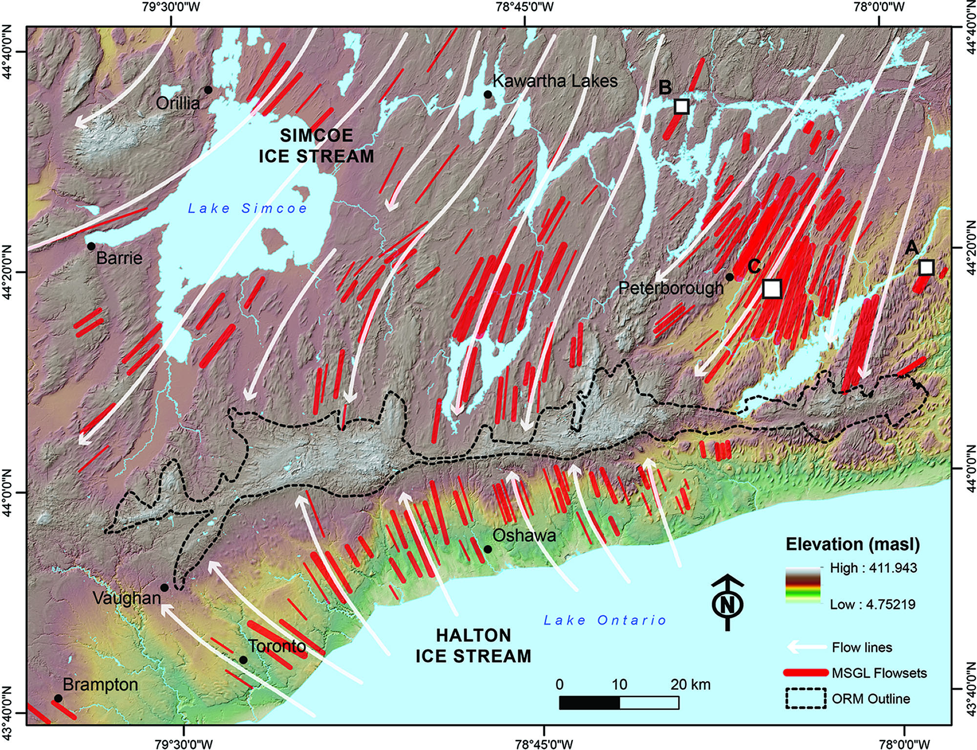
Figure 2-Depiction of flowlines derived from MSGL flowsets revealing a convergence of ice flows at the Oak Ridge Moraine. Image from Sookhan, Eyles & Arbelaez-Moreno (2019)
Want to learn more about Ontario's glacial history?
Check out the thematic trip on Ontario’s Ice Age or, for a more in-depth look, a field trip of subglacial bedforms in Southern Ontario previously offered by the lab.
Acknowledgements
Special thanks to Syed Bukhari for the sharing of the 3D visualization of the Oak Ridges Moraine
References
Shane Sookhan, Nicholas Eyles, and Lina Arbelaez-Moreno. Reply to the comment by H.A.J. Russell on “Converging ice streams: a new paradigm for reconstructions of the Laurentide Ice Sheet in southern Ontario and deposition of the Oak Ridges Moraine”. Canadian Journal of Earth Sciences. 56(8): 889-893. https://doi.org/10.1139/cjes-2019-0016