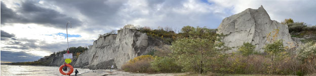
Beautiful but dangerous: Scenic spots and hazards at the Scarborough Bluffs
by Andrew Zajch, 01/17/2022
You have likely seen images on social media overlooking Lake Ontario from the top of the Scarborough Bluffs. In some cases, foolhardy photographers venture out on the precipice of the bluffs to catch their own iconic photo of the lake and beaches below (Figure 1). The popularity of the site and weakness of the bluff’s edge has led to the construction of fences and signage indicating the hazard that lies beyond (Figure 2).Read More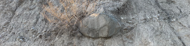
Till and boulders on the beach at East Point Park
by Andrew Zajch, 01/13/2022
East point park (see site S96: East Point) lies along the waterfront trail that straddles the northern coast of Lake Ontario. A short detour away from the trail, near the water treatment station, along the trail you will find trails and access to the beach below East Point Park. Visible from the beach are staggering cliffs predominantly composed of glacial till, a concrete like mixture of clay, silt, sand, and gravel deposited by ice sheets.Read More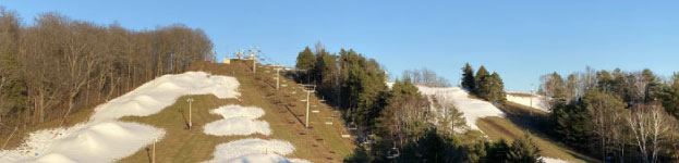
Hitting the slopes: Geology behind Southern Ontario's Ski Hills
by Andrew Zajch, 1/11/2022
As the weather gets colder and the snow starts to fall, many Ontarians eagerly await the opening of its ski hills. For those in the Greater Toronto Area there are many options to north, east and west to meet their needs in south-central Ontario (Figure 1). However, this area is not known for its towering mountain ranges so where, and why, do we get ski hills in this region. The answer, unsurprisingly, is the area’s Geology! Read More
Things are getting erratic in Buckhorn!
by Andrew Zajch, 12/16/2021
If you like big rocks, I got just the place for you! Roughly half an hour north from Peterborough you can visit the town of Buckhorn in the Kawartha region of Ontario which has three easily accessible glacial erratics.Read More
The Planet Earth Lab gets geospatial!
by Andrew Zajch, 11/26/2021
It is often said a craftsman is only as good as their tools. Similarly, researchers are often constrained by available approaches and technologies. Cognizant of this, the Planet Earth Lab is looking to harness new technology to enhance their capabilities, particularly their geospatial tools which are fundamental to their analytical approaches and visualizations of regional dynamics.Read More
From the ground up: An overview of the CBRS workflow
by Andrew Zajch, 11/22/2021
Geographic Information System (GIS) methodologies are an essential tool for glacial research looking to understand the spatial distribution and character of landforms. While manual mapping can typically be done, to optimize the use of large his resolution data sets a more efficient approach is necessary. To examine large swathes of glacially influenced terrains across North America, the Planet Earth Lab developed an approach to automate the mapping of glacial landforms termed Curvature-Based Relief Separation (or CBRS for short).Read More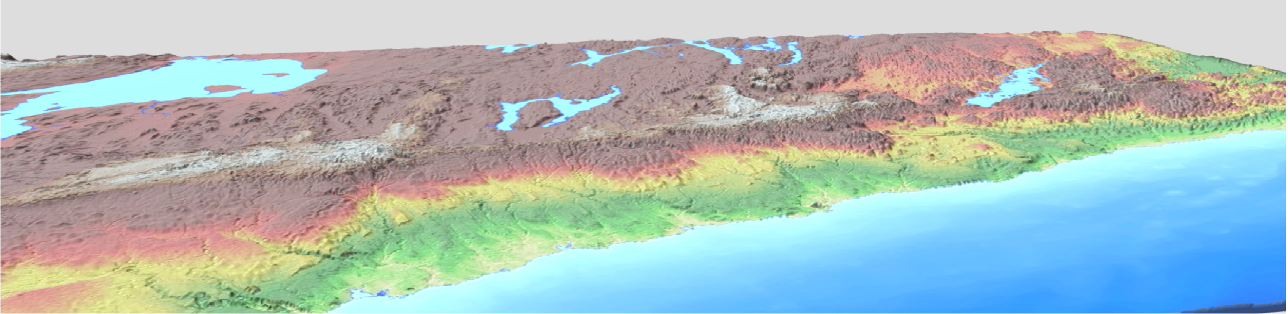
The Oak Ridges Moraine: Antarctica Revisted
by Nick Eyles, 11/22/2021
If you live out of town in central Ontario, chances are you get your drinking water from a water well that taps into groundwater stored in glacial sediments deep below. The biggest source of groundwater in the Greater Toronto Area is the Oak Ridges Moraine (ORM), an 160 km long line of hills and hummocks up to 300 m in elevation (more than 200 m above the level of Lake Ontario at 75 m above sea level) stretching from the Niagara Escarpment in the west to east of Peterborough (Figure 1). It is Ontario’s largest glacial landform and is well known among hikers and mountain bikers alike, for its many forested trails including the Trans-Canada Trail which winds its way along the summit of the ridge. The same groundwaters emerge at surface on the south side of the ridge where numerous springs feed the many rivers that drain to Lake Ontario. Read More
A new perspective: Using 3D visualizations of topographic surfaces
by Andrew Zajch, 11/17/2021
Visualizations are an essential tool for researchers studying glacial landforms. The Planet Earth lab has been using new technologies and data processing methods to develop 3D images of topographic surfaces to provide a new perspective on old problems. See an example from the Rice Lake Corridor in Ontario, a region ripe with glacial landforms (Figure 1). The adoption of 3D visualization is revolutionary in the sense that it transitions our typically used natural plane view of landforms to new points of view that help us look at the morphologies from all angles. This leads to new information about landform features and their dynamics that previously could not be discerned from conventionally used approaches and views. Read More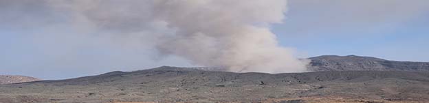
Volcanism in action- Aso, Japan
by Andrew Zajch, 11/12/2021
You may have witnessed the recent remarkable footage from the Aso Volcano, Japan, which experienced an eruption on October 20th, 2021, resulting in the spewing of menacing ash clouds that blanketed the neighboring areas. Specifically, the activity was observed at Mount Nakadake which lies at the center of relic Aso Caldera which is one of the largest calderas in the world (ASO UNESCO GLOBAL GEOPARK, 2012). This elevated the volcanic warning to a level 3, indicating that the volcano should not be approached, from a level 2 where only approaching the present caldera was to be avoided (Japan Meteorological Agency, 2021). Hearing this news, I couldn’t help but recall my trip to Japan in 2019 when I was lucky enough to travel to the Aso area, located within the Kumamoto Prefecture, during a two-day road trip through the island of Kyushu. The area is roughly 6 hours by the fastest bullet train from Tokyo, with an additional 1-2 hours needed to access the site by car or public transit. Read More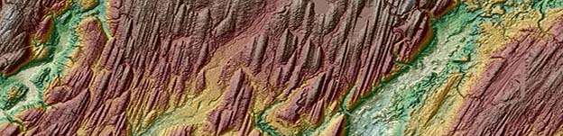
The Planet Earth Lab in Action! GAC-MAC 2021
by Andrew Zajch, 11/11/2021
At the recent GAC- MAC London 2021 joint annual conference PhD Candidate Shane Sookhan gave a talk titled “LiDAR-based quantitative assessment of drumlin to mega-scale glacial lineation continuums and flow of the paleo Seneca-Cayuga paleo-Ice Stream”. This work covered Shane’s recent PhD work that utilizes high-resolution data to map glacial landforms to shed light on the behavior of past ice sheets that once covered Ontario. Shane emphasized that the availability of high-resolution LiDAR (Light Detection and Ranging) around the great lakes has created new possibilities for identifying glacial landforms. Contrasting the high-resolution LiDAR data against lower resolution topographic data clearly demonstrates the utility of the LiDAR data for observing MSGLs (mega-scale glacial lineation), linear grooves, which are only revealed in the higher resolution image (1 m) (Figure 1). Read More
The drone has landed!
by Nick Eyles, 11/05/2021
Thanks to a substantial grant from the University of Toronto and the Department of Physical and Environmental Sciences to Professors Adam Martin and Nick Eyles, we are pleased to announce the arrival of a new drone system for eco and geo spatial mapping and analysis. The EXPERT (EXPloring Environments in Real Time) Initiative is based on a DJI Matrice 300 RTK quadcopter drone, equipped with a GVI LiAir V 3-D LIDAR mapping system, and a MicaSense Altum multispectral sensor for terrain and ecological mapping. This now providesa cutting-edge ability to map large areas with a vertical resolution of ~5 cm and to now link physical substrates, such as changing geological conditions, with the natural and agricultural ecosystems that they support (such as forests and tree covers), including those in the built environment. This creates new opportunities for interdisciplinary research and training, and to begin modelling environmental change, such as vegetative responses to climate change etc., and modification of natural landscapes as urban areas expand. Details of the underlying land surface and its geology are also revealed in stunning detail. Read More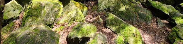
Caves and Stacks on the Bruce Peninsula
by Andrew Zajch, 10/21/2021
Recently, member of the lab set out to conduct some field work along Georgian Bay. One of the stops was the Nottawasaga Lookout Trail just south of Collingwood. This site boasts a thick forest littered with dolostone blocks that are fractured and jointed (Figure 1-2). This reflects the site’s proximity to the Niagara Escarpment whose caprock is the notably resistant dolostone. If you have ever travelled across Central Ontario you have undoubtedly noticed the escarpment darting out up and above the relatively flat topography. The escarpment extends all the way from Lake Ontario to the tip of Bruce Peninsula boasting some of the most interesting sites that Ontario has to offer such as Niagara Falls or the Bruce Peninsula National Park. Stradling the escarpment is the renown Bruce Trail. The Nottawasaga Lookout Trail is one of the many segments of the Bruce Trail which extends across the entire extent of the Niagara Escarpment. Read More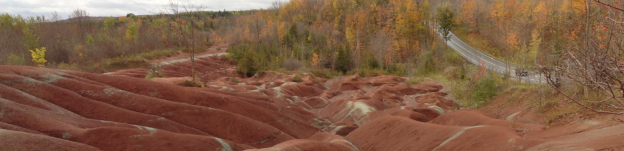
A Glimpse of Mauritius in Ontario
by Andrew Zajch, 11/05/2021
The Cheltenham Badlands exhibit an exposed area of Queenston Shale. This formation was created as the Taconic Mountains, which covered Ontario roughly 440 million years ago, were eroded and their sediments were subsequently deposited into coastal plains. The intriguing red color is due to oxidation of the iron within the shale which suggests that the sediments were originally deposited in shallow oxygen rich seas.Read More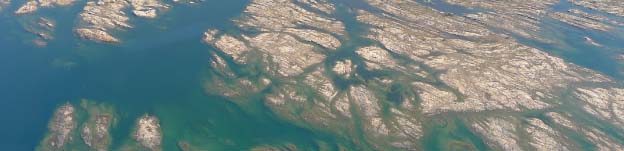
Georgian Bay UNESCO Global Geopark initiative
by Nick Eyles, 10/28/2021
The purpose of UNESCO’s Global Geopark initiative is to highlight and preserve outstanding locations around the planet that illustrate significant chapters or distinct events in Earth’s long history. Their purpose is to promote further geological research, heighten public outreach and literacy in geology and Earth science, showcase different cultural uses of landscapes and geological settings in the course of human history, and to develop ecologically sustainable geotourism for the benefit of local communities. Read More
Caves and Stacks on the Bruce Peninsula
by Andrew Zajch, 10/21/2021
The Bruce Peninsula has some of the most breath-taking views and landscapes that Ontario has to offer. These are mainly attributed to the exposure of the Niagara Escarpment which extends from Lake Ontario up to and then along the eastern edge of the Bruce Peninsula. Some of the more interesting features are the sea caves and stacks that can be found throughout the Bruce Peninsula. These represent a period in which the water levels in Georgian bay were much higher. The features, now found a distance away from the present shoreline, provide evidence of past shorelines exposed the erosive processes of waves. Read More
Undegraduate Research Experience
by Andrew Zajch, 10/21/2021
Undergraduate students are often curious about research when they enter University. I can recall my time as an undergraduate research student back in 2012 when I joined the Planet Earth Lab,I had no idea what to expect! My task was to assist with ongoing work on glacial lake bottom sediments across Ontario. This included managing past...Read More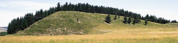
The enigma of drumlins
by Nick Eyles, 9/30/2021
The word ‘drumlin’ is an old Irish word describing an elliptical tear-shaped glacial hill left behind by the melt of large ice sheets during past Ice Ages. Every geology student will come across them sooner or later, the iconic glacial landform present in densely-packed ‘swarms’ in those areas buried by Ice Age ice sheets. A drumlin’s long axis records the... Read More
Road of Broken Dreams: Victoria Road
by Andrew Zajch, 9/3/2021
Victoria Road is one of the many colonization roads that dot the southern periphery of the Canadian Shield. These roads demonstrate the will to utilize the wilderness surrounding Georgian Bay for agriculture and settlement. Unfortunately, the high basement rock and lack of soil across the region made it... Read More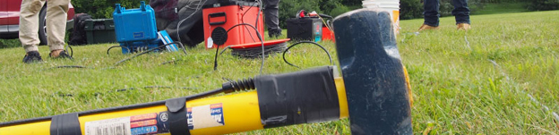
Seismic Surveying in the Valley
by Andrew Zajch, 9/3/2021
On July 30th members of the lab assisted lab technicians with the testing of seismic surveying equipment in the UTSC valley. This was in preparation for the upcoming course Exploration Geophysics (EESB21H3) offered this upcoming fall semester at UTSC. Seismic surveying is an example of geophysical methods that... Read More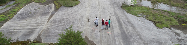
Getting Groovy with Mega Grooves
by Andrew Zajch, 8/31/2021
So what are mega grooves? They are grooves carved into the bedrock recording the velocity and direction of past ice flows. As ice flows it collects subglacial materials forming an erosive underbelly capable of carving into the bedrock analogous to sandpaper scraping across a surface. The remnants of this process... Read More
U of T News: From geology to pharmacy
by Rahul Kalvapalle, 8/9/2021
Long before the COVID-19 pandemic put a halt on travel and field trips, the University of Toronto geologist grappled with how to expose large numbers of students – particularly undergraduates taking introductory courses – to landscapes and environments, past and present, around the world. He ultimately found a solution in... Read More
U of T News: Virtual field trips...
by Geoffrey Vendeville, 7/27/2021
Virtual field trips that take geology students from the Bonnechere Caves to Potholes Provincial Park, Niagara Falls and Halfway Log Dump Bay. Digital labs that allow biomedical engineering students to observe their experiments at a nano-level. And partnerships with students in Mexico that explore the impact of COVID-19 on food security... Read More