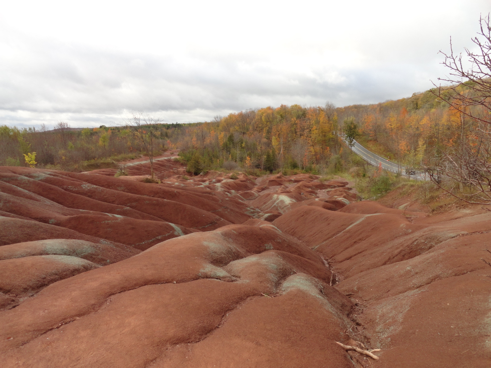
Figure 1- Chetlenham Badlands in the fall month boasts a fantastic contrast in colors
Don’t let the red earth and barren landscape fool you, this isn’t Mars but Ontario! Roughly an hour outside of the city of Toronto you can find the heritage site known as the Cheltenham Badlands (43.7760⁰ N, 79.9426⁰ W). This amazing landscape has been formed due to a distinct combination of mechanisms stemming from the formation of Ontario to the more recent anthropogenic impacts.
The Cheltenham Badlands exhibit an exposed area of Queenston Shale. This formation was created as the Taconic Mountains, which covered Ontario roughly 440 million years ago, were eroded and their sediments were subsequently deposited into coastal plains. The intriguing red color is due to oxidation of the iron within the shale which suggests that the sediments were originally deposited in shallow oxygen rich seas.
This explains the color but what about the landscape?
The gullied landscape is the result of overgrazing of cattle causing the removal of vegetation that provided a protective layer from natural erosive mechanisms. The barren slope has since then been at the mercy of the rain and surface runoff. The erosive ability of the runoff is exacerbated by the varied expansion of the different clay minerals, which make up the shale, once they become wet allowing for the formation of cracks leading to amplified erosion. The landscape is therefore the result of both human and natural processes.
However, learning about the site I couldn’t help but think that the scenic features at the Cheltenham Badlands were very similar to a notable attraction known as the Chamarel 7 colored earth geopark on Mauritius (Figure 2)(20.4251⁰ S, 57.3917⁰ E), an island found off the eastern coast of Madagascar in the Indian Ocean. Those who have watched Netflix’s Resort to Love, showcasing the natural beauty Mauritius has to offer, will likely agree with me that this is a bucket list type of destination. So, wouldn’t it be great to get a taste of what Mauritius has to offer here in Ontario?
Are they similar or is it my imagination?
Comparing the images of the two sites the scenic correlations between them are evident. Just like at the Cheltenham Badlands, the sediments at Chamarel show clear red colors which can be attributed to iron oxides. In Chamarel this comes from the weathering of basalt which formed from past volcanic activity on the island. This contrasts with the Cheltenham Badlands which are derived from eroded sediments collecting in shallow seas which have now come to the surface. The mechanisms leading to the development of the landscapes however are the same. In both cases human impacts on the environment are to blame. Sheth et al. (2010) comment that the ‘seven-coloured earth’ site at Chamarel is similarly the consequence of deforestation exposing susceptible sediments to erosion and the formation of the undulating landscape.
While the origins of the underlying geology at the two sites may differ, the similarity in the scenic features suggests that the Cheltenham Badlands provides an intriguing substitute for those interested in visiting a site like the 7 colored earth in Chamarel, Mauritius. Unfortunately, visitors shouldn’t expect an abundance of tropical fruit and a refreshing island breeze on their trip to the Cheltenham Badland, that may have to wait until visiting Mauritius.
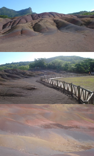
Figure 2- Images from Chamarel showing the multicolored sediments and eroded barren surface
Where can I learn more about the Cheltenham Badlands?
If you are interested in learning more about the Cheltenham Badlands check out the virtual reality tour of this site
If you are interested in visiting the Cheltenham Badlands you can find the site (search S19: Cheltenham Badlands) on the planet rocks map. Be advised that a parking reservation is required (via the credit valley conservation website) to book a 1.5 hour time slot for a visit.
Acknowledgments
Special thanks to Tracy Ng for providing the photos of Chamarel, Mauritius used in this post.
References
1. Sheth, H. C., Johnson, C. P. & Ollier, C. D. The ‘seven-coloured earth’ of Chamarel, Mauritius. J. African Earth Sci. 57, 169–173 (2010).