The Bruce Peninsula has some of the most breath-taking views and landscapes that Ontario has to offer. These are mainly attributed to the exposure of the Niagara Escarpment which extends from Lake Ontario up to and then along the eastern edge of the Bruce Peninsula. Some of the more interesting features are the sea caves and stacks that can be found throughout the Bruce Peninsula. These represent a period in which the water levels in Georgian bay were much higher. The features, now found a distance away from the present shoreline, provide evidence of past shorelines exposed the erosive processes of waves.
Bruce’s Caves
Sea caves can be found at Bruce’s Caves (44⁰46’15.0” N, 81⁰05’03.0”W) found just northeast of Wiarton (the home of the famous Wiarton Willie). A short hike will reveal these caves. In terms of the history of the area these caves depict the first stage of erosive wave action along a cliff face. As the waves hit the surface, they will form depressions as water erodes the bottom of the cliffs. Once these underlying rocks are eroded away, gravity then spurs further erosion of the overlying rocks. This results in the notable caves that are great for exploring (Figure 1).
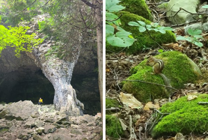
Figure 1- Caves found at Bruce's Caves (left) and some of the residents at the site (right)
Devil's Monument
The sea stack found at the Devil’s Monument site (45.1382⁰N, 81.3335⁰W), lying on the eastern coast of Bruce Peninsula in Dyers Bay, show the next stage of erosion along the cliff face. Even once sea caves form, the cliff is still subject to persistent erosion. Eventually the waves may pierce through the caves leading to the creation of an arch. As waves continue to erode the rocks on either side of the arch, this weakens the conjoining rocks overhead and can cause them to crumble. The result is a stack no longer attached to the cliff. The stack at Devil’s monument is evidence of this cycle coming to a completion in the past when water levels were much higher (Figure 2).
Ultimately, beyond boasting interesting scenic features, the sites demonstrate both the scale and magnitude of environmental changes. Comparing the sites, it is easy to consider the magnitude of the erosive processes needed to transition the caves, such as those found at Bruce’s Caves, to stacks, such as at Devil’s Monument. Furthermore, it is hard not to picture what things must have looked like during this time when wave action was eroding away the cliffs and forming these features.
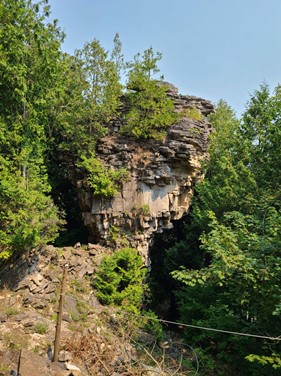
Figure 2- Sea Stack at the Devil's Monument site
Where can I find more sites like this?
Check out the Bruce’s Caves site (search W28: Bruce's Caves) on the Planet Rocks map and explore around the area, particularly along the eastern edge of the Bruce Peninsula, to find more sites that may interest you!
Acknowledgments
Special thanks to Kirsten Kennedy, Alan Yu and Patrick Peng for their pictures and help.