INTRODUCTION
The Niagara Escarpment might be best known from the tumbling of the Niagara River over the cliffs at Niagara Falls, but it is actually a 725 km long series of cliffs stretching across Southern Ontario. This landform has enormous significance in terms of its role as a barrier between Georgian Bay and the main body of Lake Huron, and is also recognized today as a unique landscape and ecosystem. The height of the cliffs is affected by somee 400 m of vertical warping of the tough 'caprock' layer (variably called the Lockport, Amabel, or Gasport Dolostone).
The highest point is just south of Collingwood, where the highest concentration of ski hills anywhere in Ontario carve their way down the Escarpments face, but it falls quickly towards the Bruce Peninsula, before descending underwater at Tobermory. Only the highest points poke up through the Main Channel to make the Fathom Five Islands, and then the caprock flexes back up to make the spine of Manitoulin Island.
The Escarpment is ecologically important due the strongly contrasting biomes created by the severe topography and it's microclimates. The base of the cliffs for example might be comprised of jumbles of large blocks of rock called talus upon which little can grow aside from Sugar Maples and White Cedars, or else relatively well-forested sediment slopes, or even descend directly into Georgian Bay. The sheer cliff face is capable of supporting "old-growth" White Cedars which root into fractures in the rock face and are sometimes over 1000 years old. The upper plateau of the Escarpment is locally devoid of sediment, and instead hosts thin crusts alvar: a type of shrubland biome that develops over carbonate rock. This biodiversity has been recognized by UNESCO who named the Escarpment a World Biosphere Reserve. The crowning achievement of local conservationists is the creation of the 700-km long network of footpaths known as the Bruce Trail which connects Niagara to Tobermory.
The Bruce Peninsula has always presented a significant obstacle in travel between Georgian Bay and Lake Huron. Oral Chippewa tradition tells of several portage and canoe routes which cut down travel times by guiding travelers across land from present day Wiarton to Port Elgin at the mouth of the Saugeen River. These routes appear on maps made by Europeans as early as 1657, so were in use well before that time.
Many European settlers were attracted to the Bruce Peninsula during government-sponsored campaigns in the 1870's and 1880's which promoted farming. However, the region is not suitable for agriculture due to the thin rocky soil, and settlers faced immense hardship as a result. Instead, settlers generally turned either to lumbering or fishing for their livelihoods. Communities sprung up around mill sites which took advantage of the power of water falling over the escarpment face.
The Main Channel of Georgian Bay has been an important shipping route since the mid 19th century, yet is hazardous due to the submerged section of the Escarpment between Tobermory and Manitoulin Island. The combination of shipwrecks, lighthouses, clear waters, a unique freshwater ecosystem, and shallowly submerged limestone rock formations makes this the 'Scuba diving capital of Canada'. Water clarity is a reflection of the surrounding geology which is dominated by relatively hard Paleozoic dolostones and limestones; while these rocks dissolve (to produce a wide range of so-called ‘karst’ features such as sinkholes and underground caves) they do not produce the muddy sediment produced by the weathering and breakdown of many other sedimentary rocks. It is protected federally as the the Fathom Five National Marine Park, which was Canada's first National Marine Park.
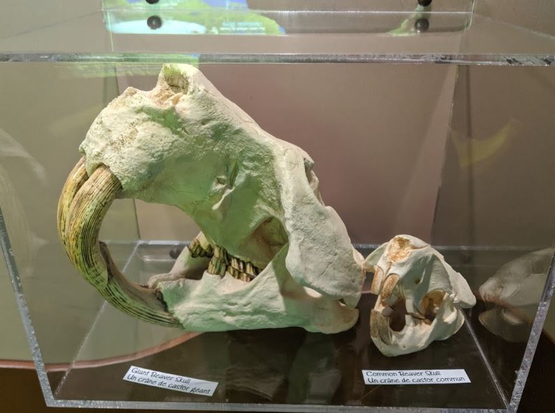
In Anishinaabe storytelling tradition, the Fathom Five Islands were formed when a dam built by Waib Amike, the giant White Beaver, broke. The islands are a part of the Manitoulin Archipelago or "Stepping Stones". This myth could have routes in the existence of the Giant Beaver, which died out about 10,000 years ago.
An important, though often under-appreciated resource available from the Escarpment today is aggregate (crushed rock) and building stone (think the large rectangular stones in stone buildings). The extraction of such resources involves quarrying, not mining. Quarrying is a shallow-surface process whereby virtually all rock removed is used, while mining usually requires a distilling step to isolate metals from rock which produces a sizeable amount of waste rock. The largest concentration of stone quarries in Ontario is at Wiarton where the Escarpment rock is well-exposed. It is estimated that it takes 18,000 tonnes of gravel to build one kilometre of highway and that if every load of aggregate used in Ontario had to travel just one extra kilometre to reach its destination job site, an extra 2.5 million litres of fossil fuel would be consumed annually. Aggregate used in the production of asphalt and concrete and is critical for the growth of cities.
In this lesson, we will explore the history, origins, and geomorphology of the escarpment.
LEARNING OUTCOMES
By the end of this lesson, you will be able to
- Trace the Niagara Escarpment from a topographic map.
- Describe a variety of processes that have shaped the Escarpment and the landforms that result.
- Outline the history of natural phenomenon shaping the Escarpment.
- Key terms: Geomorphology, drumlins, rock drumlins, Lake Algonquin, talus, fissure caves, stratigraphy, caprock, dissolution, karst, dolostone, joints, recessive